 La Pointe, François de (active 1666-90; French)
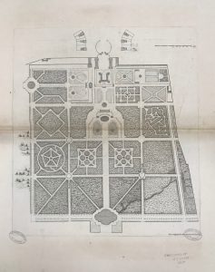
Untitled [plan of Versailles], c.1668
Engraving, 37.3 x 41.8 (plate), 59.5 x 94.5 (sheet, irreg.)
Gift of George Collins Levey 1879
National Gallery of Victoria (p.183.52-1)
= Levey gift, cat.no.83
This plan, inscribed in the plate at lower right: Leué et designé sur les lieux et gravé par F.de Lapointe, appears to correspond with the first plate listed in Suite et Arrangement (1727), under Plans & Views of Versailles, described as “Plan du Château de Versailles, sans titre,” by La Pointe.
It is closely comparable with a drawing by La Pointe, also of c.1668 (Paris, Bibl.Nat.); and also with the right half of the opening double-page plan of Versailles in Plans, veues, et ornemens de Versailles (Paris, 1679), plate 7.
La Pointe is documented as having produced a 9-part map of Paris and environs in 1674; but further information about him appears to be scanty.
Refs.
Not listed in NGV 1894 or 1905
Not reproduced in NGV catalogue; author’s ID photo shown here
Cf. Suite et Arrangement (1727), p.4 (as noted above)
For La Pointe, see Bénézit 8, p.220 (as active 1666-90); not listed in AKL. For his drawing in Paris, see Berger A Royal Passion (1994), fig.38; and for the 1679 Versailles volume mentioned, see http://arks.princeton.edu/ark:/88435/xs55md45n (facsimile ed.)